San Francisco Map with MLS Districts (Real Estate District Boundaries) - FILES - PDF and AI, editable, vector, layered, royalty free
This page is for the sale of DIGITAL FILES. Poster Print link is below or request it here
SAN FRANCISCO MLS DISTRICT MAP POSTER PRINT
SAN FRANCISCO MLS DISTRICT FILES - PDF and AI, layered, editable, vector, royalty free
PURCHASE INCLUDES:
- PDF Files - with Company Branding Box and without
- Adobe Illustrator Files and fonts (layered, editable)
- 11”x17” Vector File - enlarged or reduced to any size with out loss of quality
- Customization: Turn map layers on or off. Easily change Fonts and Colors
- Royalty Free / All Reproduction Rights Granted (not for resale)
- Prints not included, recommend GET PRINTS HERE
- NO SALES TAX!
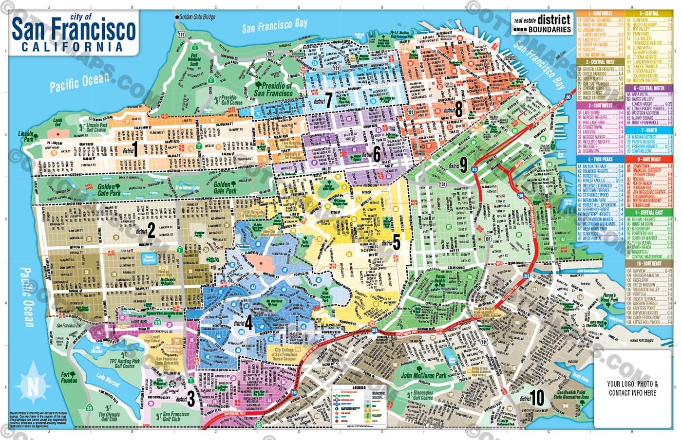
COMMUNITIES:
ALAMO SQUARE
ANZA VISTA
ASHBURY HEIGHTS/BUENA VISTA
BALBOA HOLLOW
BALBOA TERRACE
BAYVIEW
BERNAL HEIGHTS
CASTRO, THE
CATHEDRAL HILL
CENTRAL PARKSIDE
CENTRAL RICHMOND
CENTRAL SUNSET
CENTRAL WATERFRONT
CHINATOWN
CIVIC CENTER
CLARENDON HEIGHTS
COLE VALLEY
CORONA HEIGHTS
COUNTRY CLUB ACRES
COW HOLLOW
CROCKER-AMAZON
DIAMOND HEIGHTS
DOGPATCH
DOLORES HEIGHTS
DUBOCE TRIANGLE
EUREKA VALLEY
EXCELSIOR
FILLMORE, THE
FINANCIAL DISTRICT
FISHERMAN’S WHARF
FOREST HILL
FOREST HILL EXTENSION
FOREST KNOLLS
GLEN PARK
GOLDEN GATE HEIGHTS
HAIGHT-ASHBURY
HAYES VALLEY
HUNTER’S POINT
INGLESIDE
INGLESIDE HEIGHTS
INGLESIDE TERRACES
INNER PARKSIDE
INNER RICHMOND
INNER SUNSET
JAPANTOWN
JORDAN PARK
LAKE MERCED HILL
LAKE STREET
LAKESIDE
LAUREL HEIGHTS
LITTLE HOLLYWOOD
LONE MOUNTAIN
LOWER HAUGHT
LOWER PACIFIC HEIGHTS
MERCED HEIGHTS
MERCED MANOR
MIDTOWN TERRACE
MIRALOMA
MISSION BAY
MISSION DISTRICT
MISSION DISTRICT
MISSION DOLORES
MISSION TERRACE
MONTEREY HEIGHTS
MT.DAVIDSON MANOR
NOB HILL
NOE VALLEY
NORTH BEACH
NORTH PANHANDLE
NORTH WATERFRONT
OAKWOOD CIRCLE
OCEANVIEW
OUTER MISSION
OUTER PARKSIDE
OUTER RICHMOND
OUTER SUNSET
PACIFIC HEIGHTS
PARK MERCED
PARNASSUS HEIGHTS
PINE LAKE PARK
PORTOLA
PORTOLA PLACE
PORTRERO HILL
PRESIDIO HEIGHTS
PRESIDIO TERRACE
RUSSIAN HILL
SEACLIFF
SHERWOOD FOREST
SILVER TERRACE
SOUTH BEACH
SOUTH OF MARKET (SOMA)
ST.FRANCES WOOD
SUNNYSIDE
TELEGRAPH HILL
TENDERLOIN
THE GROVE
THE WOODS
TWIN PEAKS
VISITACION VALLEY
VISTA FRANCISCO
WEST PORTAL
WESTWOOD HIGHLANDS
WESTWOOD PARK
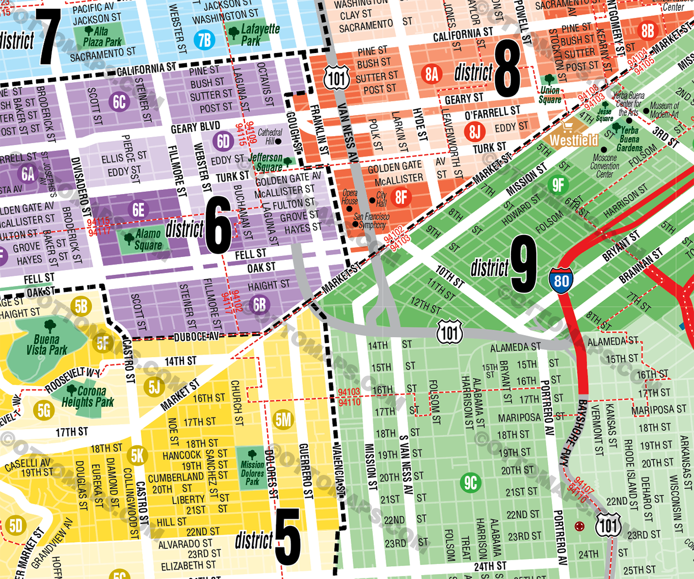
DETAILS:
- Subdivision/Tract Boundaries and Index
- Full Street Detail
- Recreation Centers
- Parks
- Shopping Centers
- Golf Courses
- Schools
RIGHTS:
- Royalty Free
- Not for resale
- All reproduction rights granted
DISCLAIMER:
- The information on this map was derived from multiple sources. Care was taken in the creation of this map. Ottographix cannot accept any responsibility for errors, omissions, or positional accuracy. However, notification of errors are appreciated. If you find a mistake, Ottographix will fix it for no charge. Please contact us and we'll take care of it. https://www.ottographix.com/contact.html, web@ottographix.com
- Maps are sold as-is. All necessary files are included for editing
- Additional customization is available from Ottographix at an additional cost. Please contact us for details and a free quote. http://www.ottographix.com/contact.html, web@ottographix.com
San Francisco Map with MLS Districts (Real Estate District Boundaries) - FILES - PDF and AI, editable, vector, layered, royalty free