Long Beach Map EAST, Los Angeles County, CA - FILES - PDF and AI, editable, vector, royalty free
...)
Regular price
$425.00
Sale price
$425.00
This page is for the sale of DIGITAL FILES. Poster Print link is below or request it here
Description
PURCHASE INCLUDES:
- PDF Files - with Company Branding Box and without
- Adobe Illustrator Files and fonts (layered, editable)
- 11”x17” Vector File - enlarged or reduced to any size with out loss of quality
- Customization: Turn map layers on or off. Easily change Fonts and Colors
- Royalty Free / All Reproduction Rights Granted (not for resale)
- Prints not included, recommend Kinkos
- NO SALES TAX!
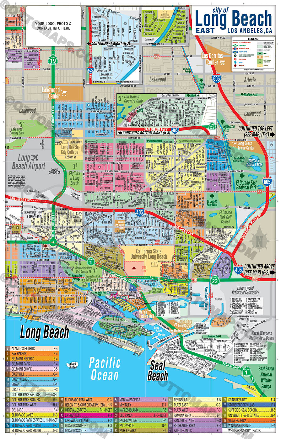
COMMUNITIES:
- ALAMITOS HEIGHTS
- BAY HARBOR
- BELMONT HEIGHTS
- BELMONT PARK
- BELMONT SHORE
- BIXBY HILL
- BIXBY VILLAGE
- BRYANT
- CIRCLE
- COLLEGE PARK EAST (SB)
- COLLEGE PARK ESTATES
- COLLEGE PARK WEST
- DEL LAGO
- EL DORADO LAKES
- EL DORADO PARK ESTATES
- EL DORADO PARK NORTH
- EL DORADO PARK SOUTH
- EL DORADO PARK WEST
- HERON PT. & GUM GROVE PK. (SB)
- IMPERIAL ESTATES
- LA ROCHELLE
- LAKEWOOD VILLAGE
- LOS ALTOS NORTH
- LOS ALTOS SOUTH
- MARINA PACIFICA
- NAPLES ISLAND
- OLD RANCH
- PACIFIC VILLAS
- PALO VERDE
- PARK ESTATES
- PENINSULA
- PLAZA EAST
- PLAZA WEST
- RANCHO ESTATES
- RECREATION PARK
- SPINNAKER BAY
- STONEYBROOK VILLAS
- SURFSIDE (SEAL BEACH)
- UNIVERSITY PARK ESTATES
- VILLA PACIFICA
- WINDWARD POINTE
DETAILS:
- Subdivision/Tract Boundaries and Index
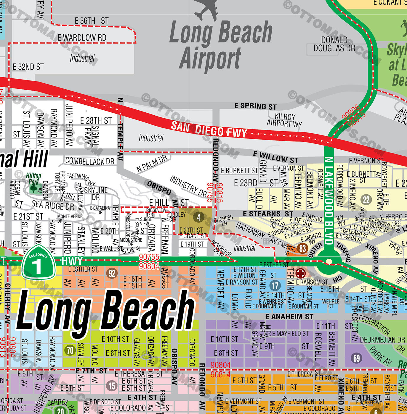
- Full Street Detail
- Recreation Centers
- Parks
- Shopping Centers
- Golf Courses
- Schools
-
- RIGHTS:
- Royalty Free
- Not for resale
- All reproduction rights granted
DISCLAIMER:
- The information on this map was derived from multiple sources. Care was taken in the creation of this map. Ottographix cannot accept any responsibility for errors, omissions, or positional accuracy. However, notification of errors are appreciated. If you find a mistake, Ottographix will fix it for no charge. Please contact us and we'll take care of it. https://www.ottographix.com/contact.html, 619.339.3129, web@ottographix.com
- Maps are sold as-is. All necessary files are included for editing
- Additional customization is available from Ottographix at an additional cost. Please contact us for details and a free quote. http://www.ottographix.com/contact.html, 619.339.3129, web@ottographix.com
Long Beach Map EAST, Los Angeles County, CA - FILES - PDF and AI, editable, vector, royalty free