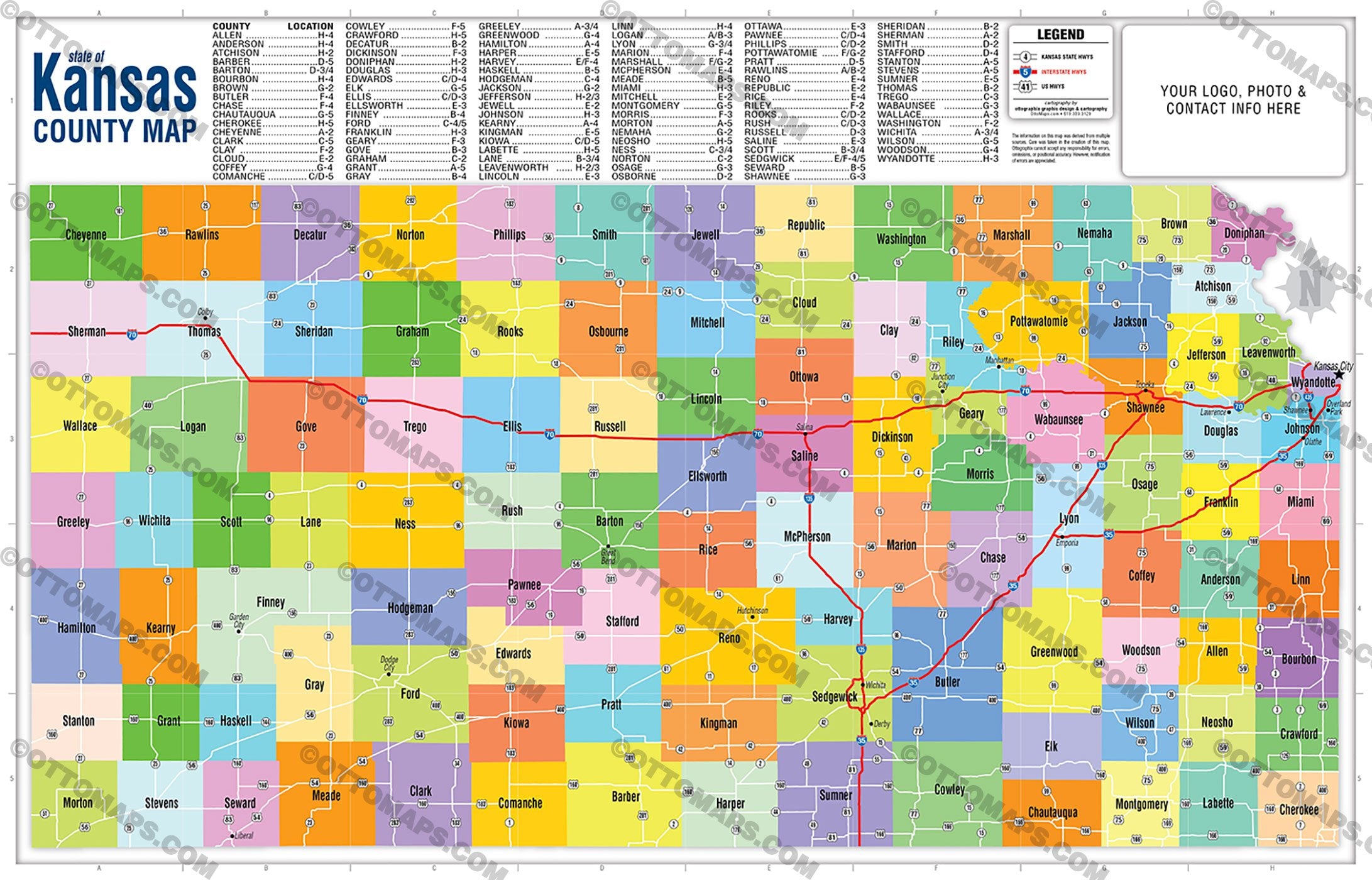
Kansas State Map - County Boundaries - FILES - PDF and AI, editable, vector, royalty free
This page is for the sale of DIGITAL FILES. Poster Print link is below or request it here
PURCHASE INCLUDES:
Ready-To-Use PDF with blank box for company branding, and
Layered, editable Adobe Illustrator CC file with fonts
SIZE: 11w x 17h - Vector Maps: enlarge or reduce to any size without loss of quality
COMMUNITIES:
- Allen County
- Anderson County
- Atchison County
- Barber County
- Barton County
- Bourbon County
- Brown County
- Butler County
- Chase County
- Chautauqua County
- Cherokee County
- Cheyenne County
- Clark County
- Clay County
- Cloud County
- Coffey County
- Comanche County
- Cowley County
- Crawford County
- Decatur County
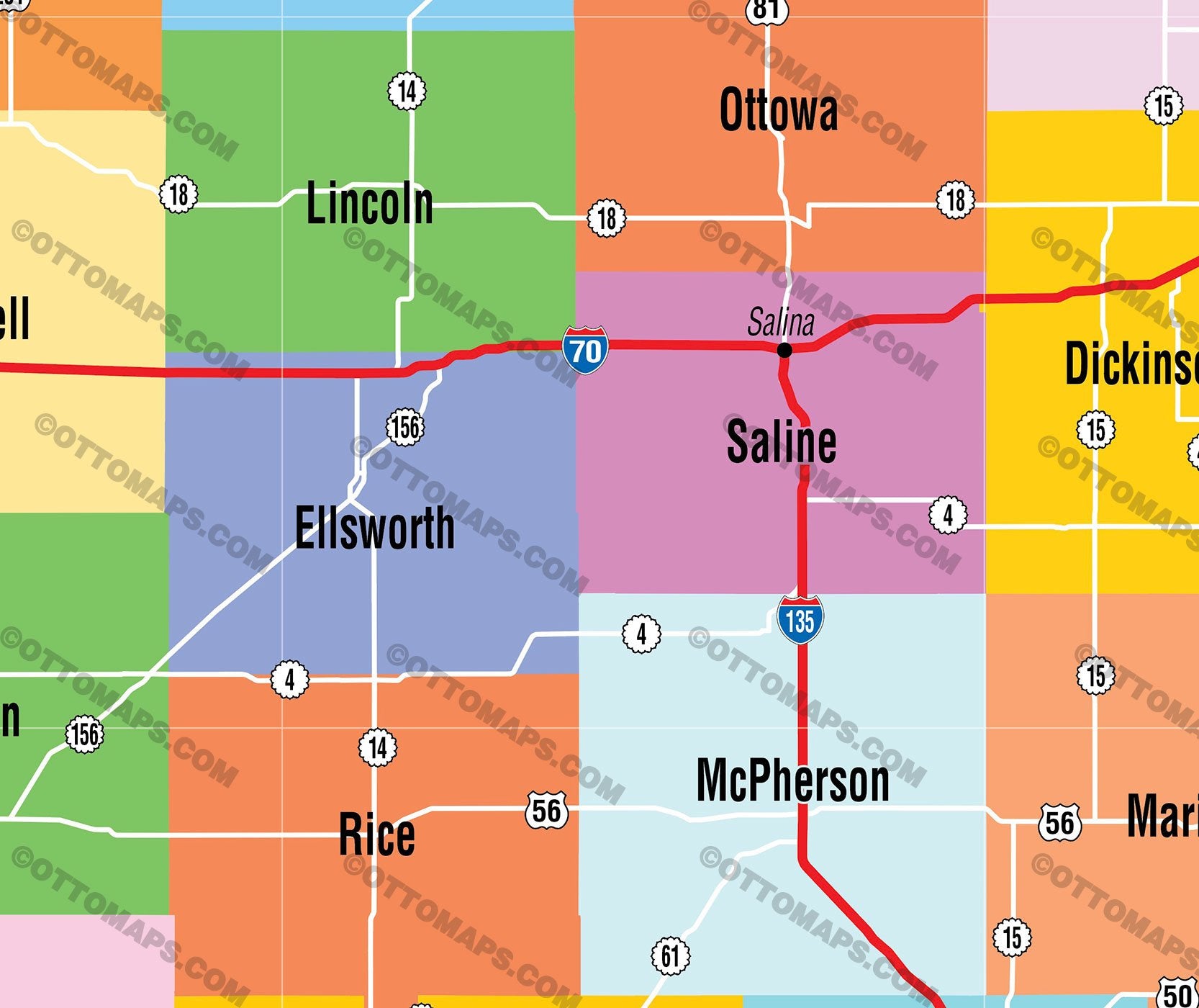
- Dickinson County
- Doniphan County
- Douglas County
- Edwards County
- Elk County
- Ellis County
- Ellsworth County
- Finney County
- Ford County
- Franklin County
- Geary County
- Gove County
- Graham County
- Grant County
- Gray County
- Greeley County
- Greenwood County
- Hamilton County
- Harper County
- Harvey County
- Haskell County
- Hodgeman County
- Jackson County
- Jefferson County
- Jewell County
- Johnson County
- Kearny County
- Kingman County
- Kiowa County
- Labette County
- Lane County
- Leavenworth County
- Lincoln County
- Linn County
- Logan County
- Lyon County
- Marion County
- Marshall County
- McPherson County
- Meade County
- Miami County
- Mitchell County
- Montgomery County
- Morris County
- Morton County
- Nemaha County
- Neosho County
- Ness County
- Norton County
- Osage County
- Osborne County
- Ottawa County
- Pawnee County
- Phillips County
- Pottawatomie County
- Pratt County
- Rawlins County
- Reno County
- Republic County
- Rice County
- Riley County
- Rooks County
- Rush County
- Russell County
- Saline County
- Scott County
- Sedgwick County
- Seward County
- Shawnee County
- Sheridan County
- Sherman County
- Smith County
- Stafford County
- Stanton County
- Stevens County
- Sumner County
- Thomas County
- Trego County
- Wabaunsee County
- Wallace County
- Washington County
- Wichita County
- Wilson County
- Woodson County
- Wyandotte County
CONTAINS:
- County Boundaries and Index
- Arterial Detail
RIGHTS:
- Royalty Free
- Not for resale
- All reproduction rights granted
CUSTOMIZATION:
- Clearly labeled layers. Turn any map feature on and off.
- Maps are sold as-is. All necessary files are included for editing
- Additional customization is available from Ottographix at an additional cost. Please contact us for deatils and a free quote! http://www.ottographix.com/contact.html, 619.339.3129, info@ottographix.com
DISCLAIMER:
The information on this map was derived from multiple sources. Care was taken in the creation of this map. Ottographix cannot accept any responsibility for errors, omissions, or positional accuracy. However, notification of errors are appreciated. If you find a mistake, Ottographix will fix it for no charge. Please contact us and we'll take care of it. http://www.ottographix.com/contact.html, 619.339.3129, info@ottographix.com
Kansas State Map - County Boundaries - FILES - PDF and AI, editable, vector, royalty free