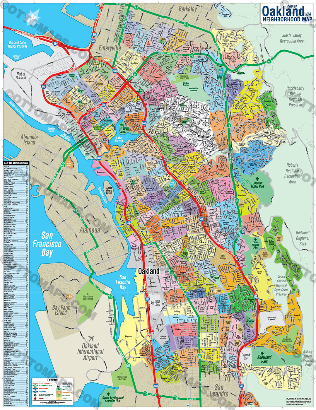
Oakland Map, Alameda County, CA - PDF, vector, royalty free - FILES - PDF and AI, editable, vector, royalty free
This page is for the sale of DIGITAL FILES. Poster Print link is below or request it here
PURCHASE INCLUDES:
Ready-To-Use PDF with blank box for company branding, and
Layered, editable Adobe Illustrator CC file with fonts
SIZE: 17w x 22h - Vector Maps: enlarge or reduce to any size without loss of quality
COMMUNITIES:
- Acorn
- Acorn Industrial
- Adams Point
- Allendale
- Arroyo Viejo
- Bartlett
- Bella Vista
- Brookfield Village
- Bushrod
- Caballo Hills
- Castlemont
- Chabot Park
- Chinatown
- City Center
- Civic Center
- Claremont Hills
- Clawson
- Cleveland Heights
- Clinton
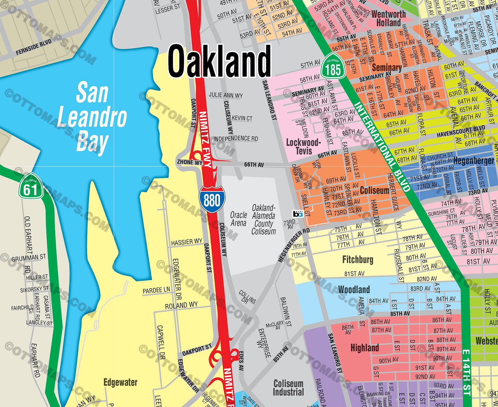
- Coliseum
- Coliseum Industrial
- Columbia Gardens
- Cox
- Crestmont
- Crocker Highlands
- Dimond
- Dogtown
- Durant Manor
- East Peralta
- Eastmont
- Eastmont Hills
- Edgewater
- Elmhurst Park
- Embarcadero
- Fairfax
- Fairview Park
- Fitchburg
- Foothill Square
- Forestland
- Fremont
- Frick
- Fruitvale Station
- Gaskill
- Ghosttown
- Glen Echo
- Glen Highlands
- Glenview
- Golden Gate
- Grand Lake
- Harrington
- Havenscourt
- Hawthorne
- Hegenberger
- Highland
- Highland Terrace
- Hiller Highlands
- Hoover/Foster
- Iveywood
- Ivy Hill
- Jack London Square
- Jefferson
- Jingletown
- Lakeshore
- Lakeside
- Las Palmas
- Laurel
- Leona Heights
- Lincoln Highlands
- Lockwood-Tevis
- Longfellow
- Lynn
- Maxwell Park
- McClymonds
- Meadow Brook
- Melrose
- Melrose Heights
- Merriewood
- Merritt
- Millsmont
- Montclair
- Mosswood
- North Stonehurst
- Northgate
- Oak Center
- Oak Knoll
- Oak Tree
- Oakmore
- Oaksterdam
- Old Oakland
- Panoramic Hill
- Paradise Park
- Patten
- Peralta Hacienda
- Piedmont Avenue
- Piedmont Pines
- Pill Hill
- Prescott
- Ralph Bunche
- Rancho San Antonio
- Redwood Heights
- Reservior Hill
- Rockridge
- San Pablo Gateway
- Sante Fe
- Sausal Creek
- School
- Seminary
- Sequoyah
- Shafter
- Sheffield Village
- Shepherd Canyon
- Skyline-Hillcrest Estates
- Sobrante Park
- South Kennedy Tract
- South Prescott
- South Stonehurst
- St. Elizabeth
- Temescal
- The Bottoms
- The Twomps
- Toler Heights
- Trestle Glen
- Tuxedo
- Upper Dimond
- Upper Laurel
- Upper Rockridge
- Uptown
- Valdez Triangle
- Webster
- Wentworth Holland
- Westlake
- Woodland
- Woodminster
CONTAINS:
- Subdivision/Tract Boundaries and Index
- Full Street Detail
- Recreation Centers
- Parks
- Shopping Centers
- Golf Courses
- Schools
RIGHTS:
- Royalty Free
- Not for resale
- All reproduction rights granted
CUSTOMIZATION:
- Clearly labeled layers. Turn any map feature on and off.
- Maps are sold as-is. All necessary files are included for editing
- Additional customization is available from Ottographix at an additional cost. Please contact us for deatils and a free quote! http://www.ottographix.com/contact.html, 619.339.3129, info@ottographix.com
DISCLAIMER:
The information on this map was derived from multiple sources. Care was taken in the creation of this map. Ottographix cannot accept any responsibility for errors, omissions, or positional accuracy. However, notification of errors are appreciated. If you find a mistake, Ottographix will fix it for no charge. Please contact us and we'll take care of it. http://www.ottographix.com/contact.html, 619.339.3129, info@ottographix.com
Oakland Map, Alameda County, CA - PDF, vector, royalty free - FILES - PDF and AI, editable, vector, royalty free