
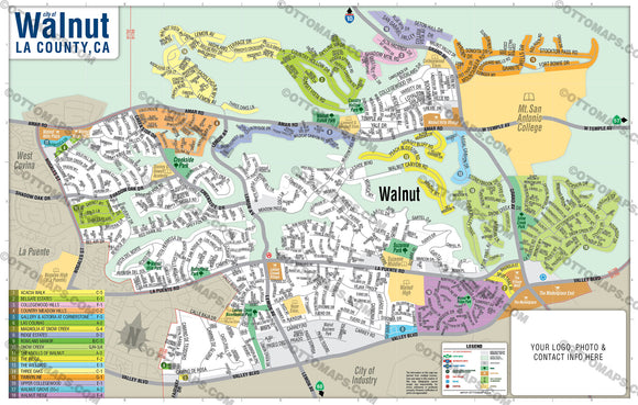


Walnut Map, Los Angeles County, CA
PURCHASE INCLUDES:
Ready-To-Use PDF with blank box for company branding, and
Layered, editable Adobe Illustrator CC file with fonts
SIZE: 11w x 17h - Vector Maps: enlarge or reduce to any size without loss of quality
COMMUNITIES:
- ACACIA WALK
- BELGATE ESTATES
- COLLEGEWOOD HILLS
- COUNTRY MEADOW HILLS
- GALLERY & ASTORIA AT CORNERSTONE
- LAS COLINAS
- MAGNOLIA AT SNOW CREEK
- RIDGE ESTATES
- ROWLAND MANOR
- SNOW CREEK
- THE KNOLLS OF WALNUT
- THE RIDGE
- THE WILLOWS
- THREE OAKS
- TIMBERLINE
- UPPER COLLEGEWOOD
- WALNUT GROVE (55+)
- WALNUT RIDGE
CONTAINS:
- Subdivision/Tract Boundaries and Index
- Full Street Detail
- Recreation Centers
- Parks
- Shopping Centers
- Golf Courses
- Schools
RIGHTS:
Royalty Free
Not for resale
All reproduction rights granted
CUSTOMIZATION:
Clearly labeled layers. Turn any map feature on and off.
Maps are sold as-is. All necessary files are included for editing
Additional customization is available from Ottographix at an additional cost. Please contact us for details and a free quote! https://ottomaps.com/pages/contact, 619.339.3129, info@ottographix.com
DISCLAIMER:
The information on this map was derived from multiple sources. Care was taken in the creation of this map. Ottographix cannot accept any responsibility for errors, omissions, or positional accuracy. However, notification of errors are appreciated. If you find a mistake, Ottographix will fix it for no charge. Please contact us and we'll take care of it. http://www.ottographix.com/contact.html, 619.339.3129, info@ottographix.com