
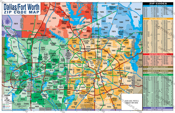


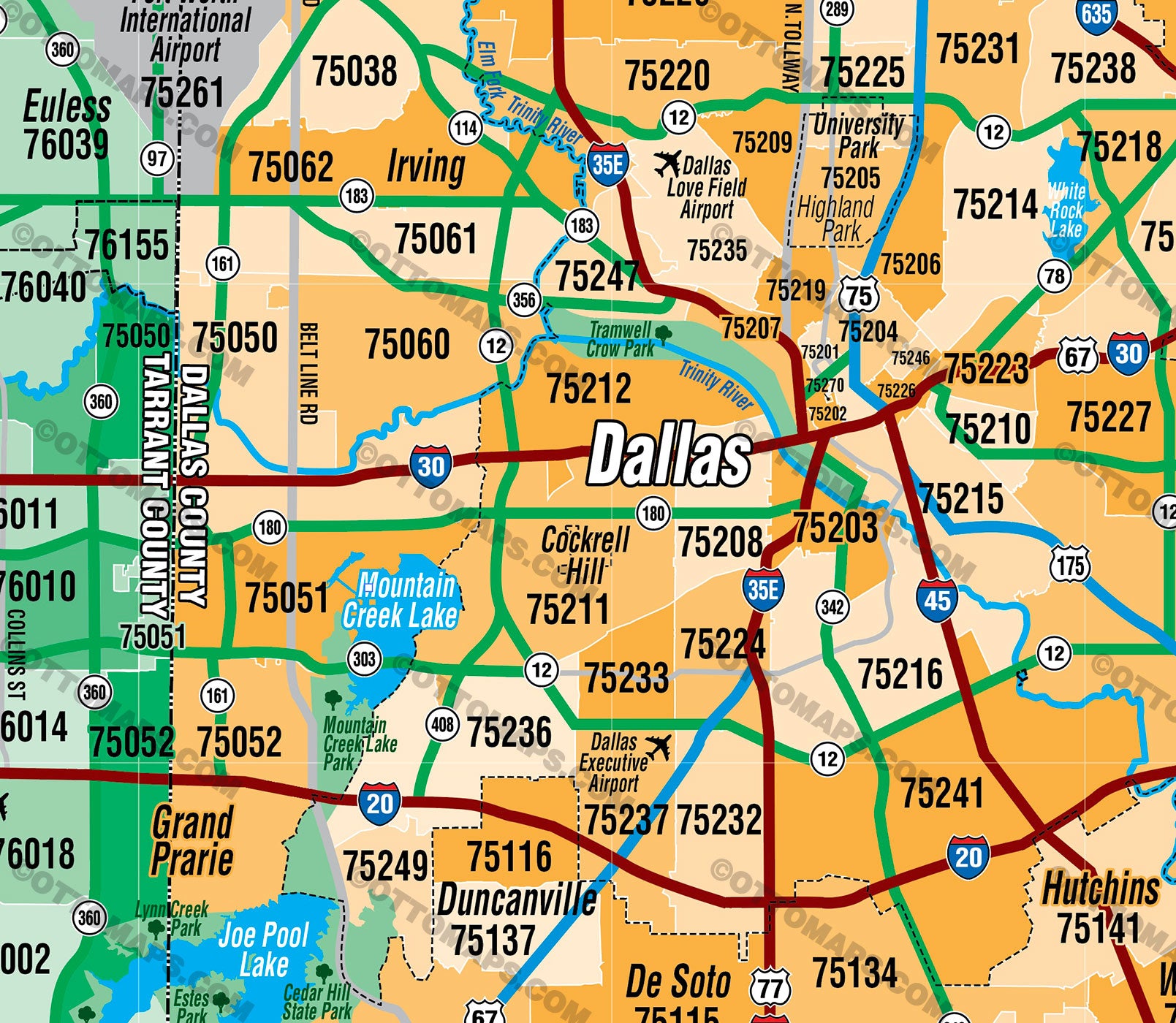
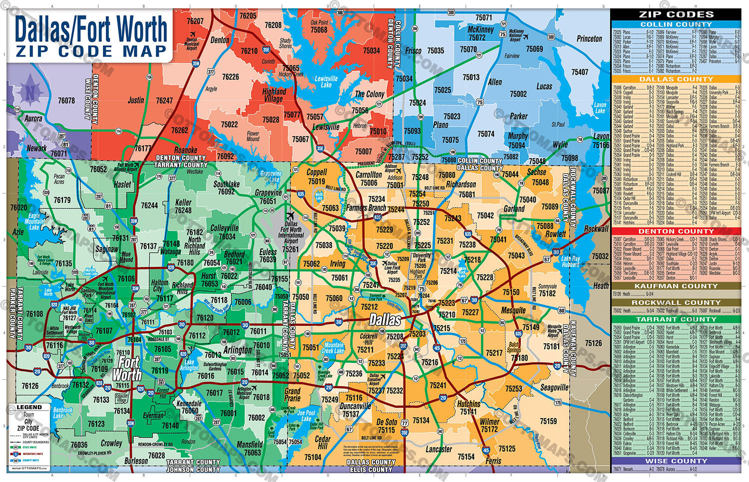
Dallas Fort Worth Zip Code Map - Counties Colorized - FILES: PDF and Adobe Illustrator Files - layered, editable, royalty free
PURCHASE MAP POSTER PRINT
PURCHASE MAP FILES (PDF, AI, editable, vector, royalty free)
Fort Worth / Tarrant County and Dallas / Dallas County Zip Code Map
OTHER OPTIONS:
DFW Zip Code Map - with Zip Codes (Zip Codes Colorized)
DFW Zip Code Map - with Zip Codes (Counties Colorized)
DFW Tarrant & Dallas Counties Map (no Zip Codes)
PURCHASE INCLUDES:
- PDF Files - with Company Branding Box and without
- Adobe Illustrator Files and fonts (layered, editable)
- 11”x17” Vector File - enlarged to any size with out loss of quality
- Files are editable with any PDF editor
- Royalty Free / All Reproduction Rights Granted (not for resale)
- Prints not included, recommend Vista Print
- No sales tax!
INCLUDES:
- Allen
- Argyle
- Arllington
- Aurora
- Azle
- Balch Springs
- Bedford
- Benbrook
- Blue Mound
- Burleson
- Carrollton
- Cedar Hill
- Cockrell Hill
- Colleyville
- Coppell
- Corinth
- Crowley
- Dallas
- Dalworthington Gardens
- Denton
- DFW Int'l Airport
- Duncanville
- Edgecliff Village
- Euless
- Everman
- Fairview
- Farmers Branch
- Ferris
- Flower Mound
- Forest Hill
- Fort Worth
- Frisco
- Garland
- Grand Prairie
- Grapevine
- Haltom City
- Haslet
- Heath
- Hebron
- Hickory Creek
- Highland Park
- Highland Village
- Hurst
- Hutchins
- Irving
- Justin
- Keller
- Kennedale
- Lakeside
- Lancaster
- Lavon
- Lewisville
- Lucas
- Mansfield
- McKinney
- Mesquite
- Murphy
- Newark
- North Richland Hills
- Oak Point
- Parker
- Pecan Acres
- Plano
- Princeton
- Rendon
- Richardson
- Richland Hills
- River Oaks
- Roanoke
- Rockwall
- Rowlett
- Sachse
- Saginaw
- Seagoville
- Shady Shores
- Southlake
- Sunnyvale
- The Colony
- University Park
- Watauga
- Westlake
- Westover Hills
- Westworth Village
- White Settlement
- Wilmer
- Wylie
DETAILS:
- Zip Code Boundaries and Index
- Arterial Detail
- Parks
- County Area Boundaries
RIGHTS:
- Royalty Free
- Not for resale
- All reproduction rights granted
DISCLAIMER:
- The information on this map was derived from multiple sources. Care was taken in the creation of this map. Ottographix cannot accept any responsibility for errors, omissions, or positional accuracy. However, notification of errors are appreciated. If you find a mistake, Ottographix will fix it for no charge. Please contact us and we'll take care of it. https://www.ottographix.com/contact.html, 619.339.3129, web@ottographix.com
- Maps are sold as-is. All necessary files are included for editing
- Additional customization is available from Ottographix at an additional cost. Please contact us for details and a free quote. http://www.ottographix.com/contact.html, 619.339.3129, web@ottographix.com